Services
Accident Site Mapping
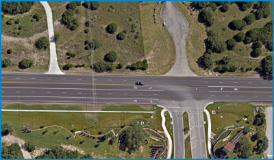
Primary Investigations along with out sister company Delta Land Surveying are experts in accurately measuring and mapping accident sites. Larry W. Busby is the owner of Delta Land Surveying, established in 1996, and is a Registered Professional Land Surveyor licensed in Texas, New Mexico, Colorado and Oklahoma and is also a Certified Federal Surveyor. These qualifications allow not only for accurate accident site mapping with total stations, GPS and a High Dynamic Range 3D Laser Scanner but provide expertise in reviewing the procedures and data collected by the police and/or other experts.ELEMENTS OF ACCIDENT SITE MAPPING MAY INCLUDE:
• Collecting additional data not collected by the police and/or other experts such as sight obstructions, traffic signs, artificial lighting and lane markings. • Creating scale maps for presentation in court or during arbitration, mediation and depositions. • Establishing right-of-way and sight easement lines. • Determining the grades and slopes of the accident scene. • Creating 3D animations of the accident reconstruction from laser scanned point clouds. HIGH DYNAMIC RANGE 3D LASER SCANNING: Primary Investigations is one of the few accident reconstruction firms in Texas to offer reconstructions based on data (point clouds) collected with an HDR Laser Scanner. A HDR Laser Scanner collects literally millions of data points during a scan and each point has a specific coordinate with allows measurements to be derived between points with a 2mm accuracy +/-. Additionally all of these points are combined into a “point cloud” from which 3D models can be created of the accident scene and vehicles. The 3D virtual models are then used to create realistic video animations of the accident.

Primary Investigations
Texas Investigation Firm License No. A17699
© Primary Investigations - All Rights Reserved.


Minim quis fugiat
deserunt velit qui
cillum reprehenderit
anim amet est non
deserunt
Services
Accident Site Mapping
Primary Investigations along with out sister company Delta Land Surveying are experts in accurately measuring and mapping accident sites. Larry W. Busby is the owner of Delta Land Surveying, established in 1996, and is a Registered Professional Land Surveyor licensed in Texas, New Mexico, Colorado and Oklahoma and is also a Certified Federal Surveyor. These qualifications allow not only for accurate accident site mapping with total stations, GPS and a High Dynamic Range 3D Laser Scanner but provide expertise in reviewing the procedures and data collected by the police and/or other experts.ELEMENTS OF
ACCIDENT SITE
MAPPING MAY
INCLUDE:
• Collecting additional data not collected by the police and/or other experts such as sight obstructions, traffic signs, artificial lighting and lane markings. • Creating scale maps for presentation in court or during arbitration, mediation and depositions. • Establishing right-of-way and sight easement lines. • Determining the grades and slopes of the accident scene. • Creating 3D animations of the accident reconstruction from laser scanned point clouds. HIGH DYNAMIC RANGE 3D LASER SCANNING: Primary Investigations is one of the few accident reconstruction firms in Texas to offer reconstructions based on data (point clouds) collected with an HDR Laser Scanner. A HDR Laser Scanner collects literally millions of data points during a scan and each point has a specific coordinate with allows measurements to be derived between points with a 2mm accuracy +/-. Additionally all of these points are combined into a “point cloud” from which 3D models can be created of the accident scene and vehicles. The 3D virtual models are then used to create realistic video animations of the accident.